
Daily diary from the Inca Trail with photos
In August 2023, we completed the classic 4-day/3-night Inca Trail in Peru. Each day of the trek was filled with the most incredible scenery, history, and physical feats.
Before the trek, I was worried it wouldn’t live up to its hype or that I would think it wasn’t as special or stunning of a place as Patagonia.
Luckily I was so wrong! The Peruvian Andes deserve as much praise and glory as their southern counterparts in Chile and Argentina.
If you are contemplating hiking the Inca Trail, this blog post will describe the daily highlights (and some low points) from our time on the trail in August.

View of Machu Picchu from Huayna Picchu
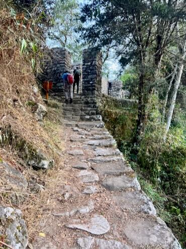
Day 1 on the Inca Trail
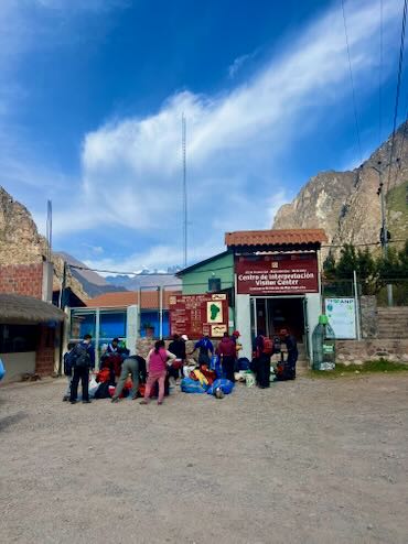
The first day on the trail was the second to easiest day, only behind day four. After being picked up in Cusco by our guide at 6 am, we drove to the trailhead in Ollantaytambo where we joined our team of porters organizing gear, food, and packs.
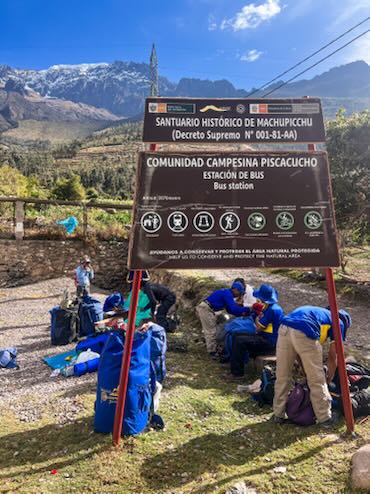
Before officially embarking on the trek, all groups must check in at the trail control point to show the required permits and passports.
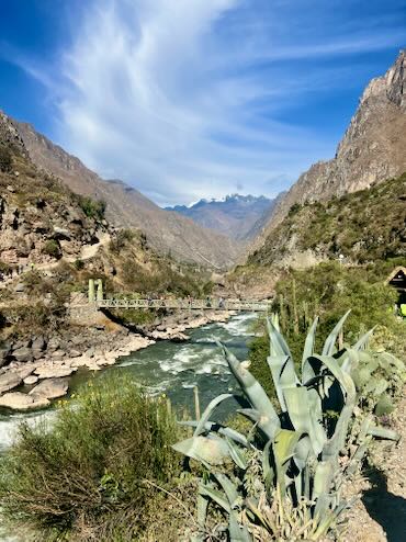
The 4-day trail officially begins once you’ve crossed the Urubamba River!

The Trail
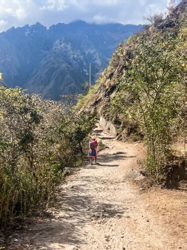
The trail on day one is mostly flat and consists of hard-packed dirt. There are a few quick, steep inclines but nothing like the inclines you will encounter on days two and three of the trek.
We hiked along the Urubamba River and through a couple of small villages. These villages sell water, sports drinks, and snacks. They also have clean bathrooms available for 1 Sol.

Rest Stops
Several shaded rest spots along the trail are much appreciated as the first day can be warm at lower elevations.
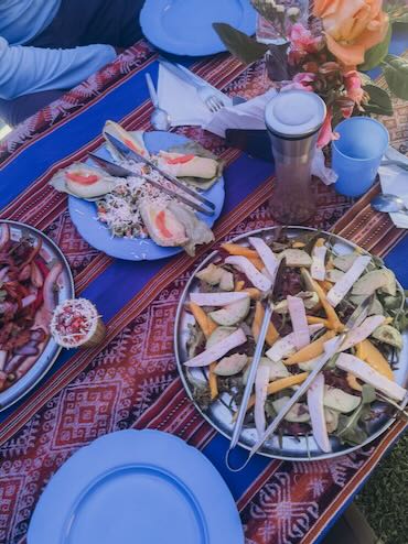
Our first lunch spot was in one of the last villages along the trail. Here was our first glimpse at how efficiently the porters set up the lunch tent and prepared our meal.

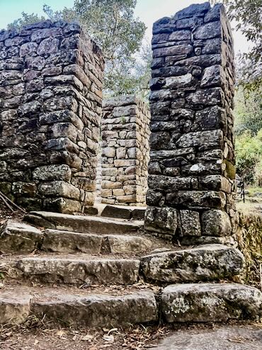
Inca Ruins
Our first of many Inca sites was Llactapata or High City in Quechua. It is strategically located at a fork in the valley.
Go right and you will reach Machu Picchu in half a day. This was known as the commercial path.
But turn left and it will take four days to reach Machu Picchu. This route was typically used by the Incas to cleanse and renew their energies while traveling to Machu Picchu.
It is also the path that we followed!

Wayllabamba Campsite
We camped at Wayllabamba campground which sits at 9,842ft of elevation and is located in the last village along the trail.
Our campsite was technically a family’s front yard. It was spacious with views of Mount Veronica. One of the best features is the private, standalone bathroom which includes a mirror, toilet, and warm shower.

We arrived at Wayllabamba around 4 pm on the first day, having hiked around 6 miles. We had two hours to get settled, shower, and rest or read until happy hour in the dinner tent.
The “happy hour” is a daily occurrence on the trail and consists of hot tea and usually a sweet or savory snack like cookies or freshly popped popcorn. At 7 pm dinner was served.
The stars at Wayllabamba were amazing, especially the Milky Way and the Alfa Crux constellation – the southern hemisphere’s North Star.
Day 2 on the Inca Trail
After a mostly restful sleep, we were awakened with steaming hot coca leaf tea and warm water to wash our faces.
Following a hearty breakfast and more coca tea, we said goodbye to our Wayllabamba campground and set off for our most challenging day on the trail.

The Altitude
Day two is known as the trail’s most challenging day. It starts right away with a steep climb to a checkpoint. At the checkpoint, there is a fun drawing that shows the altitude changes on the trail.

Following the checkpoint, we continued to climb until we reached the Ayapata Campground, about 1.3 miles from Wayllabamba.
This is the last place along the trail where we could buy drinks like water, soda, Powerade, even beer and liquor, and snacks from village vendors.

Dead Woman's Pass
From the Ayapata Campground, the trail goes nowhere but straight up to Dead Woman’s Pass. The climb is slow and grueling. With each step, the intensity of the altitude and your shortness of breath becomes more apparent. But there is zero rush to make it to the top of the pass in a rush.
Hikers go at their own pace and are only encouraged to pick it up if the guide fears they won’t make it to their campsite before dark.
Our guide told us in his 20 years of working on the Inca Trail, only one time one of his hikers wasn’t able to complete the second day.

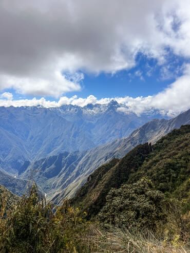
The climb to the top of the pass is mostly exposed. On a very sunny day, the heat would double the challenge. Lucky for us, it was very overcast. However, the clouds did clear momentarily to expose the incredible views of the mountains and glaciers across from Dead Woman’s Pass.

On Top of the World at Dead Woman’s Pass
3 hours after we departed the Wayllabamba campground, we arrived at the top of Dead Woman’s Pass. We began the morning at 9,842ft of elevation and reached 13,828ft at the pass.
Before starting the Inca Trail, we’d heard stories about this section of the trail and how grueling of a hike it can be. But as with many things, it is impossible to truly understand how physically and mentally demanding this portion of the trail would be.

The feeling at the top of the pass was as if we had already reached Machu Picchu, even though it was only day two of four. Everyone was over the moon, elated to have conquered the hardest section of the trail.
After some time at the top to savor our accomplishments and take a million photos, we started our descent to Pacaymayo Valley where we would camp for the night.

The descent down into the valley was beautiful. As we hiked down, thick clouds rose slowly from the valley and the temperature dropped significantly. It felt like we were in a Lord of the Rings or Harry Potter movie – the scenery was that magical.

Pacaymayo Valley
Pacaymayo Valley Campsite
It took us another two hours to reach our second campsite. It was a gorgeous spot, with 360 views of mountains, just below Dead Woman’s Pass.
Just as we got settled at camp, a thunderstorm rolled in and we could see snow starting to cover Dead Woman’s Pass and the other mountain tops nearby.

Pacaymayo Valley Campsite
Our camp chef at dinner that night, surprised us with a freshly baked cake. Yes, it was prepared and baked at the campsite! The homemade treat was even iced and decorated to commemorate the day’s accomplishment.
Our final reward was more magnificent starry skies.

Day 3 on the Inca Trail

Sunrise at Pacaymayo Campsite
Night two in the tent was the coldest I’ve felt sleeping in a tent. Despite having a Patagonia Nano and Cotopaxi down jacket plus Smart Wool layers, it was tough to shake the chill for a good night’s sleep.
That morning though we woke to a beautiful sunrise lighting up snow-dusted mountain tops from the previous night’s snow. Some fresh pancakes also helped cure sleepiness and prepared us for the longest day of the trek.

Another Tough Climb
Like day two, day three started with an immediate, intense climb. Many fellow hikers appeared in much worse shape on day three than on day two while climbing Dead Woman’s Pass.
There were scenes of vomiting, crying, and lying down on the side of the trail. Some groups might have enjoyed themselves too much celebrating the completion of Dead Woman’s Pass and were now paying the price.
")
Day Three Ruins
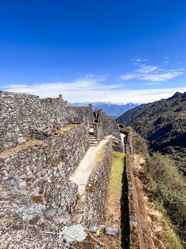
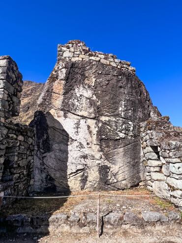
After the initial climb, we reached our first Inca ruins for the day – Runkurakay. This semi-circle-shaped ruin sits at 12,300ft. Given its strategic location overlooking Dead Woman’s Pass and the valley, it is thought to have been used as a place of rest for travelers on the Inca Trail and a lookout spot to spy on outsiders.

Runkurakay
From Runkurakay, we hiked down towards our second ruin of the day, Sayacmarca. But before reaching one of the coolest ruins on the trek, we were greeted with amazing views of Mount Pumasillo and the Vilcabamba Range.
Sayacmarca means “standing people” in Quechua. This site was given this name because it is on the edge of a mountainside, and its walls appear to be “standing” straight up from the mountain’s edges.

Discovered by Hiram Bingham in 1915, it is thought that this ruin served as a residence and spiritual site. Unlike our visit to Runkurakay which was very crowded, we had Sayacmarca completely to ourselves for 20 minutes (the perks of hiking fast in a small group!)
One of my favorite parts of Sayacmarca is an Incan Huaca or sacred monument depicting a man “running towards” Machu Picchu. It reminded me of our ultimate goal of reaching Machu Picchu.

Sayacmarca Ruins on the left with the Vilcabamba Range
From Sayacmarca we passed through the super picturesque Chaquicocha campground. Some groups stay at this site on night two of the trek instead of in the valley.
Between Sayacmarca ruins and the Wiñay Wayna ruins, the vegetation on the trail changes dramatically from aired mountainscapes to lush tropical forests. Between November and March, hikers have the opportunity to see a multitude of orchids along this section of the trail.

Lunch at Phuyupatamarka
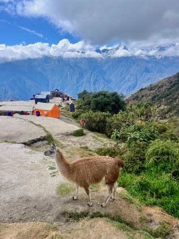
Our day three lunch spot was one of the trek highlights. We stopped at the Phuyupatamarka campground, also known as the place above the clouds. This site sits above Machu Picchu Mountain, which looks more like a hill from here.

Phuyupatamarka is where most hikers will receive their first cell phone service since beginning the hike. The signal is strong enough to make phone calls. We smiled at photos of our two dogs in Brazil that we had received while without service.
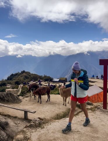
In addition to cell service, Phuyupatamarka has llamas!

Phuyupatamarka can be a final campsite on the trek in place of Wiñay Wayna but it’s about a 5-hour hike from the Sun Gate (first views of the Citadel). Hikers who sleep here won’t reach the Sun Gate at sunrise but much later in the day. However, the sunsets and sunrises at Phuyupatamarka are supposed to be incredible.
In the book, Turn Right at Machu Picchu, John Leivers who has spent many years of his life exploring the Peruvian Andes, argues that camping at Phuyupatamarka and seeing the sunrise over Mount Machu Picchu is one of the best parts of hiking the Inca Trail.

A quick cat nap post lunch at Phuyupatamarka
The Long Way Down from Phuyupatamarka to Wiñay Wayna
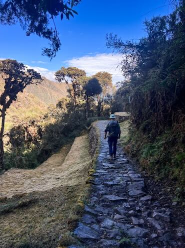
From Phuyupatamarka much of the remaining trail on the third day is straight down. Wearing two pairs of socks is key to avoiding blisters from the hundreds of steps down. My knees had never felt more sore on a hike than after this descent.

Intipata Ruins
Our final ruin site before reaching the Wiñay Wayna campground was Intipata.

Intipata Ruins
Intipata consists of huge farming terraces built into a mountainside overlooking the Urubamba River. Crops cultivated here, and at other nearby sites, were used to feed the Incan populations at Machu Picchu and Sayacmarca where farming was less conducive.

Intipata Ruins
Visiting Intipata is optional and adds an extra 40 minutes to the hike to Wiñay Wayna. There we again had the privilege to be the only hikers wandering through the rows of terraces.

Intipata Ruins
We took a moment to relax on one of the wide grassy terraces, taking in the roaring river below, the serene valley, and the imposing mountains surrounding us.
Our guide called this one of his favorite places on the trail to reflect. Although the end of the trek was starting to feel close, Machu Picchu was still just out of sight.

Wiñay Wayna
Less than 30 minutes away is the final and most densely packed campground of the trek – Wiñay Wayna. Our tent was in the last row of sites, not far from the trail to the Sun Gate checkpoint.
This campsite was my least favorite. Our guide warned us before we left Cusco that Wiñay Wayna would be busy and loud. He even recommended we bring earplugs if we had them.
At Wiñay Wayna porters from every group are busy cleaning and preparing for the hike-out to the Aguas Calientes train station the next day.
The Final Campsite
The campsites are small and tightly packed. My biggest complaint with this campsite was the bathrooms though. Wiñay Wayna is not the most remote campsite on the trail but the bathrooms would’ve said otherwise.
Before the trek, I imagined that the pit toilets would be like the ones in US National Parks, where there is still a toilet seat. Nope, these pit toilets are more like shower drains. I’ll let you imagine the rest of the situation. The bathrooms at Wiñay Wayna made the bathrooms on the W Trek in Patagonia or Vale do Pati in Chapada Diamantina look like spas.

Our final dinner of the trek
At the end of the day, we were thoroughly exhausted and rundown from the hundreds of stairs and altitude. The remainder of our food provisions were cooked up for our final dinner.
Before bed, we had time to thank each of our porters and the camp chef personally for making our trek such an amazing experience. This is also the moment to give the porters and the chef their hard-earned tips.
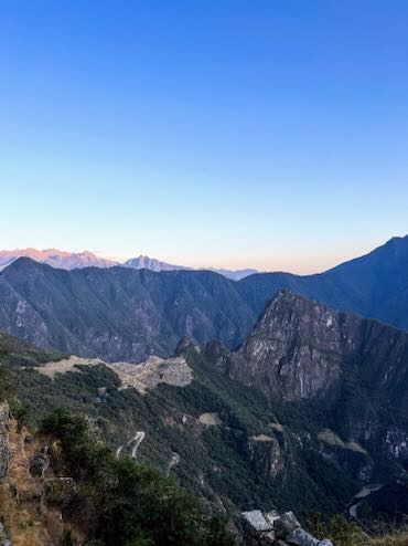
Day 4 on the Inca Trail
Our final day retracing the steps of the Incas started with a 3:30 am wake up to be some of the first hikers to pass through the Sun Gate on our final leg to Machu Picchu. We had just enough time to enjoy one last hot coca tea as we quickly dressed and packed up. Breakfast was quick and light. We were also given a hefty snack bag.
3:30 am seemed like an absurd time to be waking up, especially since it would be the day with the shortest and easiest mileage. The reason for the early start time is because the trail to the Sun Gate opens at 5:30 am and groups start lining up as early as 3 am!
The Sun Gate Checkpoint
There are a couple of covered wood benches and once those fill up the only option is to sit on the cold ground or stand. It was very cold and dark waiting for the checkpoint to open. A few big groups had passed our campsite while we were still packing up and filling the benches. We used our Therm-a-rest pads to sit on the ground. I passed the time reorganizing my pack and taking a cat nap.
A Race to the Finish
At 5:30 am when the checkpoint opened, it felt like a race to get to the Sun Gate. Whereas every other day on the trail had felt mostly uncrowded and laid back, this morning was the opposite as we practically speed-hiked in a single file line most of the way.
Eventually, a few groups peeled off to the side to remove layers or take a break. We also passed a big group on a very steep and rocky scramble, lovingly referred to as the “Gringo Killer” by guides.
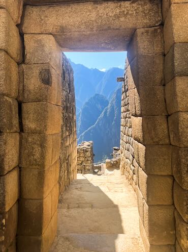
Intipunku - The Sun Gate

Sunrise at the Sun Gate
After 2 miles at a frantic pace, we reached Intipunku or the Sun Gate. This was the original entrance to the citadel and passage was strictly controlled by the Incas.
While we weren’t the first group to pass through that morning, seeing the Incan citadel in the distance for the first time brought feelings of accomplishment and exhilaration.
The sky couldn’t have been clearer as the sun was just starting to come up over the horizon. Oftentimes groups arrive at the Sun Gate and all of Machu Picchu is coated in a thick cloud layer, totally obstructing the amazing view.
I recommend taking pictures right when you first arrive, especially if you’re one of the first groups. It becomes a little hectic once more groups show up and it is nearly impossible to get a photo without a stranger in the background.
Renewed Energies
It felt surreal standing at the Sun Gate and looking down at the massive citadel. With the trek coming to a close, we were finally able to grasp why the Incas used this journey to renew their energies.
We had just spent four days trekking up and down mountains to reach this exact moment. We hadn’t even arrived at Machu Picchu yet but this view alone made all the exhaustion, shortness of breath, and soreness worth it.

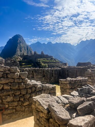
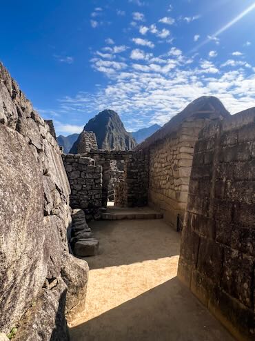
Machu Picchu and Huayna Picchu

Final Stretch to Machu Picchu
From the Sun Gate, the walk to the entrance of Machu Picchu is an enjoyable mile. The entire walk offers continuous views of the site. We had another round of photo opportunities on what is called the inferior platform.

Structural Integrity of the Ruins
Machu Picchu, and many of the Inca sites along the trail, were never found by the Spanish after conquering the Incas. It is why in 1911 when Hiram Bingham “rediscovered” the ruins, by then covered in vegetation and being farmed by a couple of families, much of the stonework was practically untouched!

Built around 1450, Machu Picchu wasn’t the last city of the Incas as Bingham thought but a mountain retreat with residences, farming terraces, and ceremonial areas.
")
Touring Machu Picchu
Before touring the ruins, hikers exit the controlled area and reenter civilization for the first time since starting the trek. Visits to Machu Picchu are strictly controlled and organized.
There are a few different types of tickets depending on which areas of the ruins you visit and if you add on additional hikes like Huayna Picchu.
Moreover, your ticket will have a specific entry and exit time. Backpacks bigger than 16x14x8” are prohibited and must be stored in a locker at the gate. Hiking sticks are also prohibited.
There are no bathrooms once you pass the guard gate and reentry is not permitted. (Our guide was able to get us reentry to use the bathroom before hiking Huayna Picchu.)

Our entry time into Machu Picchu was 8 am to 10 am and our Huayna Picchu hike start time was at 10 am. By 12:30 pm we were already outside the controlled area waiting to board the shuttle bus to Aguas Calientes.
Touring the ruins with a guide is 100% recommended although not required. Without someone familiar with the ruins it is really hard to understand and appreciate what you’re seeing. There is little signage or description throughout the ruins.
Huayna Picchu
Hiking to the top of Huayna Picchu was a memorable part of the day. Huayna Picchu is the mountain that rises directly above Machu Picchu.
Every day 400 permits are given to climb its steep steps to the top for a bird-eye view of the citadel. These permits always sell out and need to be reserved several months in advance.
After reading many reviews about how steep the trail is and how it can easily cause episodes of vertigo, I was a little apprehensive.
However, our group felt that while it was a lot of climbing, the trail wasn’t quite as vertical as we had expected it to be. There is also a railing along most of the trail to help stabilize and comfort hikers.
Final Thoughts on the Inca Trail
We finished off our Inca Trail experience with beers and delicious Peruvian food at one of Aguas Calientes’ mainstays – Full House before catching the 2 pm train back to Ollantaytambo.
Retracing the steps of the Incas along a centuries-old Inca Trail is a once-in-lifetime experience that should be on everyone’s bucket list. The sights along the trail – man-made and natural – are simply breathtaking.
If you want to learn more about the exploration and history of Machu Picchu head over to my recommended travel reading page. Authors like Hiram Bingham, Mark Adams, and High Thomson are must-reads before visiting!
The Cusco region of Peru has so much beauty to offer in addition to the Inca Trail and Machu Picchu. Below is more inspiration and planning tips for your trip to Peru.
0 Comments